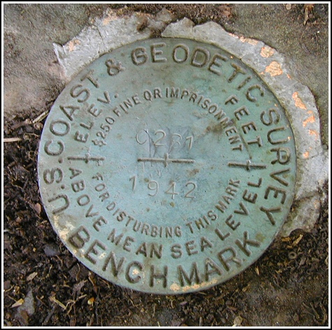
C 281 (NA0423)
C 281
Spatial/elevation data
| Coordinates | N 42.174916° W 74.019333° |
| Elevation | 558.81 ft. |
| Location | New York
Greene County Kaaterskill Quad |
Mark description
| Type | Bench Mark Disk |
| Setting | Boulder |
| Monumented | 1942 by NGS |
| Description (NGS) | NGS Datasheet |
NGS recovery information
Descriptive text
Recovered in good condition. The former library building is now privately owned. The station is approximately 8.7 feet north-northwest of a ledge on the southeast side of the boulder, and 22.7 feet northwest of a 2.5 x 2.5 x 5 foot stone column on the west side of the entrance to Dunrovin Drive. Autonomous (non-corrected) handheld GPS coordinates for the station are 42 10 29.88(N) 074 01 9.42(W).Narrative and photographs
The former site of the Palenville Free Library was the first stop on our late-Summer Kaaterskill Falls adventure. The building was unmistakable and sat in the center of town, looking just like an old library or other public building, though we did not see any signs. We parked in the small lot adjoining the front yard and began our benchmark search. The mark was found as described on a boulder just off the north shoulder of Route 23A, near a small grove of trees separating this little garden alcove from the yard itself. The disk is in good condition with legible stamping. We took photographs and measurements, and were soon on our way.
My curiosity aroused, I couldn’t resist approaching the building to see if I could find any sign of its present use. What a surprise I had when I pushed the intercom button and heard a nasty voice on the other end: “What do you want?!” I asked if the woman knew anything about the history of the building, and when the library had moved out. She snapped back that she had no idea, and wouldn’t say anything more. I thought I spotted a carved cornerstone on the southeast corner of the building, so I began to walk over to it to check out the date. The “woman” (a teenage girl) appeared above me at a window and had a fit! She started screaming at me to leave and just kept saying “this is private, get out”. I told her that nowhere on the grounds is there any indication of that fact, and that she had no reason to be so rude and confrontational. I left it at that. What an incredibly nasty person. My later attempts to research the ownership of the building turned up nothing.


N 42° 10.498’ W 074° 01.157’
Recovered in good condition.
This second order vertical control station was found as described. The historical directions are still usable, except what once was the Palenville Free Library appears to be under private ownership now. The station is roughly 8.7 feet north-northwest from the ledge on southeast side of the boulder, and 22.7 feet northwest of a 2½ x 2½ x 5 foot stone column on the west side of the entrance to Dunrovin Drive. At the station a Garmin GPSmap76 receiver with remote active antenna was used to record autonomous (non-corrected) coordinates which were roughly 33.8 feet from the scaled coordinates listed in the NGS datasheet. The mark is well exposed, in good condition, and the stamped designation is legible.
~Rich in NEPA~


