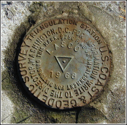
LASCO
Spatial/elevation data
| Coordinates | N 41.59125° W 76.005383° |
| Elevation | 1486 ft. |
| Location | Pennsylvania
Wyoming County Meshoppen Quad |
Mark description
| Type | Triangulation Station Disk |
| Setting | Square Concrete Monument |
| Monumented | 1968 by NGS |
| Description (NGS) | NGS Datasheet |
NGS recovery information
Descriptive text
The station mark and reference marks 1 and 2 were recovered in good condition. Powerline pole 919 is also numbered SBFC 7. The azimuth mark was searched for but was not located. U.S. Route 6 has been widened to 5 lanes in the area of the culvert, and a local resident indicated that the field near the wire fence was recently excavated for a new sewer line running parallel to the highway. The 7 by 10 foot boulder and the witness post could not be found.Narrative and photographs
Stations LASCO and DIETRICH (LZ1848) looked to be two of the most interesting on our “tour” of Tunkhannock area tri-stations. We were curious about the fact that there were two triangulation stations, both apparently still viable, placed within a few hundred feet of each other.
One further curiosity was the mention in the description of the subsurface mark being stamped FLOREY while the surface marks are stamped LASCO. We later learned the reason from Mr. Steve Lasco himself (see LZ1848) . The plan had been to name the station after the feature on which it’s located—Florey Knob—and the first disk had been stamped so already, according to Mr. Lasco. However, at his request the remaining disks were stamped LASCO.
Arriving at the site of this mark, the more southerly of the two, we found an open field bordered on one side by brush and on the other by the road we’d come in on. The reference marks are located within the brushy area but were not difficult to find. Our attention was drawn to reference mark 1 by two thin metal stakes adjacent to the monument, possibly set to indicate its position. Grass had grown over and partially obscured the station mark, but it is now well exposed.
A search later in the afternoon for the azimuth mark was unsuccessful. A resident informed us of the recent roadwork that had widened the highway and altered the area along the fenceline. Several weeks later, Mr. and Mrs. Lasco drove to the bottom of the hill to search for the disk. They reported that unfortunately, the boulder and mark—which had been quite conspicuous, they said—are no longer visible.


Recovered in good condition.
This second order triangulation station is situated on the southerly end of the ridgeline of Florey Knob, in a grassy farm field roughly 4.8 airline miles northwest of Tunkhannock. The 1968 “to reach” directions are still applicable. A handheld GPS receiver made locating the station a relatively easy task.
The historical description leads reliably to the station and the two reference marks. The station is roughly in the center of a mowed field on the left (north) side of the farm lane, and the two reference marks are located along the brushy western edge. RM1 is 15 inches south of 2 thin metal rods. Powerpole number 919 is also numbered SBFC 7.
The azimuth mark was searched for but not found. The highway (Rt. 6) has been widened in the area of the concrete culvert to 5 lanes. In addition, a local resident indicated that the pasture near the wire fence was recently excavated for a sewer line which runs parallel to the highway. The metal witness post and the 7 by 10 foot by 18 inch boulder could not be located as described.
At the station a Garmin GPSmap76 receiver with active remote antenna was used to record WAAS-corrected coordinates which were 6.1 feet from the adjusted coordinates listed on the NGS datasheet. All three marks are well exposed, in good condition, and the stamped designations are legible. ~Rich in NEPA~


| Designation | Status | Condition | Image |
|---|---|---|---|
| LASCO RM 1 | Recovered | Good |
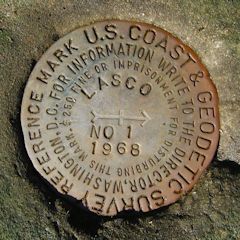
|
| LASCO RM 2 | Recovered | Good |
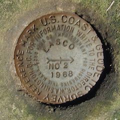
|