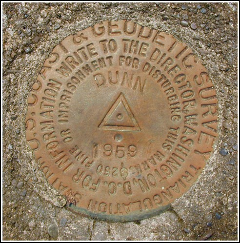
DUNN
Spatial/elevation data
| Coordinates | N 41.350933° W 75.57535° |
| Elevation | 1864 ft. |
| Location | Pennsylvania
Lackawanna County Moscow Quad |
Mark description
| Type | Triangulation Station Disk |
| Setting | Square Concrete Monument |
| Monumented | 1959 by NGS |
| Description (NGS) | NGS Datasheet |
NGS recovery information
Descriptive text
The station mark and reference mark 2 were recovered in good condition. The station is approximately 12 feet east of a 12-inch diameter dead tree with a standard metal witness sign. Reference mark 1 is in poor condition with only the shank remaining. Reference mark 2 is southwest, not north, of the station and witness sign. New route description follows. To reach the station from the junction of PA Routes 307 and 690 in Moscow, travel 2.0 miles northwest on PA Route 307 to a paved road right (Blue Shutters Road). Go northeast on Blue Shutters Road for 0.6 miles to a woods road south. Go south on the woods road for 0.55 miles to a Y intersection and a clearing on the left (east) side, then northeasterly on a woods road for 0.25 miles to the top of the hill and the station on the right.Narrative and photographs
Our recovery of DUNN was one of my last benchmarking adventures on my first mountain bike. Rich and I rode from my house in Scranton along Elmhurst Boulevard to Blue Shutters Road, and then turned into the woods on the woods road we suspected would take us to DUNN. We’d driven back here once before (staying more on the "main" woods road rather than taking the forking road toward DUNN) so we had a good idea what type of terrain we’d encounter. With the bikes, travel was easy and we soon reached the top of the knoll. It took only a minute to spot the old witness sign nailed to a dead tree. We made the mistake of assuming the witness sign had originally been placed on the tree and the measurements had been taken from that spot, and we were thus a little worried when we couldn’t find the station mark after a good ten minutes of searching. Rich finally spotted the concrete monument, half-buried and a good 12 feet east (rather than 6 feet south) from the witness sign. We concluded that the sign had been moved at some point.
It was simple to find where RM 1 had once been set. Unfortunately, the monument has been vandalized and the disk is gone. The monument is located as described, and is now situated in the middle of the track road going over the hilltop and through the rock wall.
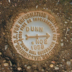
RM 2 posed another challenge. As usual, we initially followed the written description and were thus searching north of the witness sign and station, even though it didn’t make much sense (RM 1 is also roughly north of the witness sign and station). We eventually resorted to the box score and discovered that RM 2 is actually southwest of the witness sign and station. This knowledge brought us directly to the monument and marker. The disk is in good condition.


N 41° 21.057’ W 075° 34.521’
Station recovered in good condition.
This second order triangulation station is situated near the southeast end of a flat-topped wooded hill. The 1959 “to reach” directions are not quite usable any longer. Approach is made from Blue Shutters Road, going northeast from the junction of Rt. 307 for 0.6 miles to a track road south, then 0.55 miles to a Y-intersection and a small clearing on the left (east). From the east side of the clearing follow a woods road (which is accessible with a high ground clearance vehicle) northeasterly for roughly 0.25 miles to the hilltop and the station on the right. A handheld GPS receiver was helpful for navigating to the station.
The station mark is set in the top of a square concrete monument, about 2 inches above the level of the ground, and 12 feet east of a battered witness sign nailed to a 12-inch diameter dead tree.
The concrete setting for RM1 was located but the mark has been vandalized, with only the stem remaining. The monument itself protrudes about 6 inches above ground level and is located at the point where the trail splits and circles around in a small grassy clearing just south of the rock fenceline.
The 1959 historical description errs with regard to RM2 which is actually southwest of the station and witness sign, not north. It is roughly 10 feet north-northwest of the doubletrack trail, and flush with the level of the ground.
At the station a Garmin GPSmap76 receiver with active remote antenna was used to record WAAS-corrected coordinates which were less than 6 feet from the adjusted coordinates listed on the NGS datasheet. The station mark and RM2 are in good condition and the stamped designations are legible.
~Rich in NEPA~


.")


| Designation | Status | Condition | Image |
|---|---|---|---|
| DUNN RM 1 | Recovered | Poor |
|
| DUNN RM 2 | Recovered | Good |
|