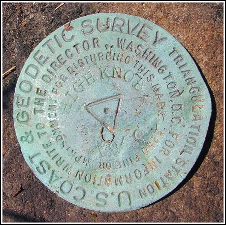
HIGH KNOB (LY2678)
HIGH KNOB
Spatial/elevation data
| Coordinates | N 41.299958° W 75.124174° |
| Elevation | 2055 ft. |
| Location | Pennsylvania
Pike County Pecks Pond Quad |
Mark description
| Type | Triangulation Station Disk |
| Setting | Rock Outcrop |
| Monumented | 1940 by NGS |
| Description (NGS) | NGS Datasheet |
Narrative and photographs
(Logged on April 20, 2003)
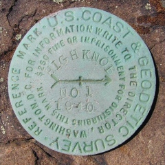
Aaron and I located RM 1 and the station mark very easily—the coordinates and description led directly to them. We could not, however, locate a rock outcropping the given distance and direction from the station that might have held the second reference mark. Similarly, we did not locate the azimuth mark even though I felt quite sure we were in or near the correct spot. I consider this a work in progress!
Update: January 1, 2004
This find is still in progress! On a sunny, brisk New Year’s Day, Rich and I hiked to the top of High Knob in search of this set of marks. I’ve been anxious to return since last April, when I was unable to locate RM2 and the azimuth mark. The weather was beautiful until we reached the top of the Knob, when we were hit with a wind cold and strong enough to make the thought of performing the usual recovery duties unpleasant. Rich located RM1 and the station mark quickly but he decided to pass on documenting them, and the nearby fire lookout tower, until a later—warmer!—date. The measurements given in the box score led us to the area where RM2 should be located, but we were unable to find the mark at this time. A rock outcropping in the correct spot is buried beneath soil and gravel that have frozen as hard as concrete and were impenetrable by the small trowel we had brought.
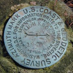
We decided to search instead for the azimuth mark, which we did locate. It is necessary to travel only approximately 1.45 miles south-southwest on the gravel road from its intersection with Route 402—slightly less than the distance noted in the 1959 recovery text. We did travel too far at first, realized this and then walked back northeast along the gravel road, following the reverse of the bearing given from the station to the azimuth mark. When our GPSrs indicated the correct bearing, we stopped and looked to the west side of the road where Rich spotted the mark immediately. The Camp Biff Trail is still clearly distinguishable directly across the gravel road from the mark, though the sign no longer exists. The mark is located near the intersection of the main gravel road and a woods road northwest, set in a small (2.5 foot x 1.5 foot) outcropping boulder that projects six inches. The mark is approximately 10 feet north of PP&L Co. powerline pole 27615/72294/N42280, 3.5 feet northwest of a green and white sign “Three Pines 19C-916”, and 21 feet northwest of the centerline of the gravel road.

(Recovered on January 1, 2004)
Station recovered in good condition.
This first order triangulation station is situated atop High Knob in a section of Delaware State Forest near Pecks Pond. For the station and its two reference marks the 1959 “to reach” directions are still adequate. A handheld GPS receiver was helpful in locating the station, and extremely useful in pinpointing the location of the azimuth mark.
The station mark and RM1 were found as described. RM2 was not found and is believed to have been covered over by 1 to 2 feet of compacted rocky fill used for construction of the road and turnout area. Measurements were made from the station according to the box score distance and bearing, we dug down several inches and probed the bottom of the hole hoping to strike solid rock, but didn’t have any luck. The mark most likely is still there, and since RM1 is intact we decided not to disturb this spot any further.
The description for the azimuth mark requires the following revisions. From Rt. 402 go roughly 1.4 miles south-southwest and then south along Hobday Road to a gated track road west, a green & white metal sign “Three Pines 19C-916,” and the mark on the right. The sign for Camp Biff Trail no longer exists, but the trailhead is still quite visible (opposite the gated track road and the “Three Pines” sign). The mark is set in the top of the north end of a 2½’ x 1½’ outcropping boulder, about 6 inches above ground level, 21 feet northwest of the centerline of Hobday Road, 10 feet north of powerpole number PP&L 27615 72294 N42280, and 3½ feet northwest of the “Three Pines” sign.
At the station a Garmin GPSmap76 receiver with active remote antenna was used to record WAAS-corrected coordinates which were identical (within 0.001 minute) to the adjusted coordinates listed on the NGS datasheet. All marks, except for RM2, are well exposed and in good condition, and the stamped designations are legible.
~Rich in NEPA~


.")
| Designation | Status | Condition | Image |
|---|---|---|---|
| HIGH KNOB AZ MK | Recovered | Good |
|
| HIGH KNOB RM 1 | Recovered | Good |
|
| HIGH KNOB RM 2 | Not Found | Unknown (Not Found) |

|