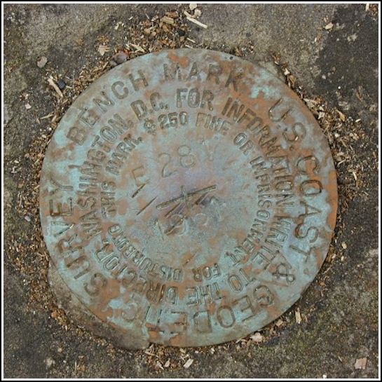
E 281 (LY1598)
E 281
Spatial/elevation data
| Coordinates | N 41.366633° W 75.576433° |
| Elevation | 1576.20 ft. |
| Location | Pennsylvania
Lackawanna County Moscow Quad |
Mark description
| Type | Bench Mark Disk |
| Setting | Boulder |
| Monumented | 1961 by NGS |
| Description (NGS) | NGS Datasheet |
Narrative and photographs
(Rich noted the technical details, so I’ll tell the story.) On this cloudy, cool morning Rich and I took a nice ride along Elmhurst Boulevard so that he could photograph “Roar 2 RM5” (LY2715). After taking care of that, Rich surprised me with the datasheet for this marker. The decision was made to go a few more miles down the road and search for it.
We cleared off several boulders before I accidentally spotted the benchmark disk on another nearby rock (while watching the Springbrook Township truck pass us for the fourth time). It was less than five feet from where we were standing. As Rich mentioned, its condition is good, and the mark wasn’t far from the coordinates listed on the datasheet.


N 41° 21.998’ W 075° 34.586’
This vertical control station is about 5.5 miles east and south-southeast along Elmhurst Blvd from the intersection with Lake Scranton Rd (or 3.17 miles south-southeast of LY2715 “ROAR 2 RM5”, or 0.63 miles north-northeast along Elmhurst Blvd from the intersection of Blue Shutters Rd). The historic description leads reliably to the site. There is an iron gate across the gravel road leading to the picnic grove, with the station on the opposite side of Elmhurst Blvd, next to an overgrown woods road. At the station mark my Garmin GPSmap76 receiver indicated 87.5 feet from the NGS datasheet coordinates. The disk is in good condition, well exposed, and the stamped designations are legible. Zhanna and I biked up from Scranton to search for this together and we are sharing the find. (Good eyes, Zh!) ~Rich in NEPA~


