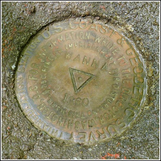
WANNA (LY1248)
WANNA
Spatial/elevation data
| Coordinates | N 41.229955° W 75.493136° |
| Elevation | 1877.21 ft. |
| Location | Pennsylvania
Monroe County Tobyhanna Quad |
Mark description
| Type | Triangulation Station Disk |
| Setting | Square Concrete Monument |
| Monumented | 1960 by NGS |
| Description (NGS) | NGS Datasheet |
NGS recovery information
Descriptive text
The station mark and reference marks 1 and 2 were recovered in good condition. The witness post near the station is still in place, although the sign is gone. The azimuth marks (both the original and the reset) were searched for but not found. The station and reference marks are located within Gouldsboro State Park. The station is most easily reached via the Old Route 611 Trail beginning at its intersection with PA Route 507. Walk southeasterly on the trail for about 0.2 miles to the station on the left and the reference marks on the right.Narrative and photographs
Triangulation stations in easy-to-access locations like state parks are typically low-stress and lots of fun to recover. For some reason, we hadn’t realized until last week that WANNA was located inside Gouldsboro State Park, but once we discovered this fact, we made it our main goal for the day.
Our first attempt today to access WANNA was foiled by a particularly nasty swamp along the Old Route 611 trail. We came to within a few hundred feet of our targeted location for the reset azimuth mark, but the depth of the mud made us rethink our plan. We retraced our path along Old 611 and the old park entrance road back to the car, and drove out to Route 507 to approach the station from the northwest instead.
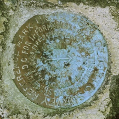
From this direction, it was an easy hike of about 0.2 mile along Old 611. The adjusted coordinates and a witness post (without sign) brought us directly to the location, but the marker and monument weren’t visible. We used the given distance and direction from the witness post to determine where to dig. After a few minutes, we had the disk and monument uncovered from under an inch of soil and leaves. Both the disk and monument are in excellent condition, probably due to having been buried for years.
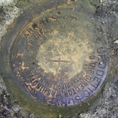
The reference marks were even easier to locate. We spotted both boulders from the station and made the finds quickly. The RM disks are also in very good condition, and because they are so close, there is a clear line of sight between both RMs and the station.
The azimuth mark—well, that’s a completely different story. Data exists for two azimuth marks for this station: the original, set in 1960, and the reset, from 1966. This is nothing unusual. What is somewhat unusual is that there is no definite statement that the original azimuth mark was destroyed, just that it was likely to be. So might it still exist? We wondered about this, and thought it would be worth looking for after finding the reset azimuth mark, which we didn’t expect to be too much of a challenge.
We hiked a bit further southeast along Old 611, keeping in mind that the reset azimuth mark is supposed to be about 0.55 miles from where 611 intersected Route 507 (the beginning of the current Old 611 trail). At approximately the correct distance, we found a track road (now a trail) leading north-northeast and, about 150 feet in, we found a large boulder matching the description. We were so sure the reset azimuth mark would be on this boulder but, to our extreme surprise, it wasn’t. Nor were there any other boulders anywhere nearby! Everything seems to point to this having been the correct location, but the disk simply isn’t there. Rich even joked that maybe the mark is still in the back of someone’s truck and was never actually set. It is interesting that there is no data in the box score for the reset azimuth mark. We’re planning to investigate further and perhaps return to the site if we have another insight.
Also of interest: we wondered why the original azimuth mark is supposedly so far away: 9.6 miles along Route 611 from its intersection with Route 507. Rich’s guess is that we found a typo and 9.6 miles was intended to be 0.6 miles, which obviously puts it in the same general area as the reset azimuth mark. This dimension, taken along with the angle from the station, puts the original azimuth mark in the median of I-380, which probably means that it’s long gone, or under so much fill that it’s not recoverable.
It was truly an awesome day filled with some finds, some misses, and sightings of a cub and momma bear, three or four scarlet tanagers, an osprey, and a small snake.


| Designation | Status | Condition | Image |
|---|---|---|---|
| WANNA AZ MK RESET 1966 | Not Found | Unknown (Not Found) |

|
| WANNA RM 1 | Recovered | Good |
|
| WANNA RM 2 | Recovered | Good |
|