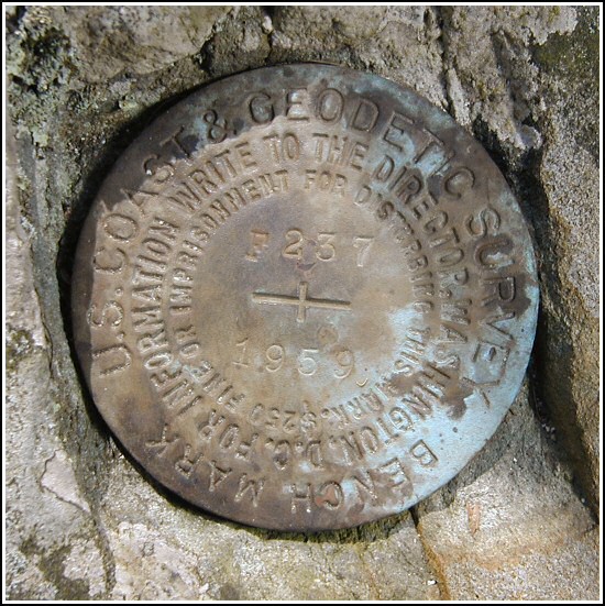
F 237 (LY1152)
F 237
Spatial/elevation data
| Coordinates | N 41.354966° W 75.102366° |
| Elevation | 1342.51 ft. |
| Location | Pennsylvania
Pike County Pecks Pond Quad |
Mark description
| Type | Bench Mark Disk |
| Setting | Boulder |
| Monumented | 1959 by NGS |
| Description (NGS) | NGS Datasheet |
NGS recovery information
Descriptive text
Recovered in good condition on Blooming Grove Hunting and Fishing Club property, as described.Narrative and photographs
F 237 was our second targeted mark for the day. After an interesting experience of finding a mark in a destroyed setting up on Blooming Grove Road, this one turned out to be a more typical search. With a few necessary modifications due to the interstate highway which now passes through the area, we were able to follow the original to-reach quite easily onto property owned by the Blooming Grove Hunting & Fishing Club (which we have obtained permission to enter). The mark was found set in an outcropping boulder, as described, at the base of an oak tree whose roots partially envelop the rock. The disk is in very good condition.


N 41° 21.298’ W 075° 06.142’
Recovered in good condition.
This second order vertical control station is set in the top of a 4 foot by 2 foot by 15 inch high outcropping boulder that is partially enveloped by the base of a 2-foot diameter oak tree. It is on property owned by the Blooming Grove Hunting & Fishing Club. The historical description was sufficiently helpful in finding the station, however the to-reach directions have changed slightly since I-84 was constructed. From Rt. 402 in Blooming Grove travel 1.1 miles east on Blooming Grove Road to the entrance of the Blooming Grove Hunting & Fishing Club (there is a small stone pavilion on the left) and the east-most of two private gravel roads on the right (south). Travel southerly for 1.13 miles, passing under both lanes of the Interstate highway, to the second gravel road on the left, then south for 0.18 miles to the mark on the left. The station is 43 feet east of the centerline of the road. At the station a Garmin GPSmap76 receiver with remote active antenna was used to record autonomous (non-corrected) coordinates which were roughly 42.8 feet from the scaled coordinates listed in the NGS datasheet. The mark is well exposed, in good condition, and the stamped designation is legible.
~Rich in NEPA~


.")