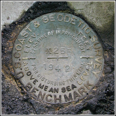
X 255 (LY0149)
X 255
Spatial/elevation data
| Coordinates | N 41.734466° W 74.189483° |
| Elevation | 666.55 ft. |
| Location | New York
Ulster County Gardiner Quad |
Mark description
| Type | Bench Mark Disk |
| Setting | Concrete Culvert |
| Monumented | 1942 by NGS |
| Description (NGS) | NGS Datasheet |
NGS recovery information
Descriptive text
Recovered in good condition.Narrative and photographs
After finding the nearby A Bear in the Gunx geocache, Rich and I took a stroll across the highway from the Mohonk Preserve Visitors’ Center to search for this mark. We found it well-preserved on a culvert that is, unfortunately, not so well-preserved. The area directly surrounding the mark seems solid, though the concrete on other areas of the headwall is crumbling. The mark was found as described using the historic description, except that we were unable to locate any definite indication of “highway survey station number 44+00”. The station designation has been painted in yellow on the highway shoulder just east of the guardrail, with an arrow indicating the direction to the mark.


Recovered in good condition.
This second order vertical control station is set in the top of the northwest headwall for a concrete box culvert under Rt. 44. The historical description was sufficiently helpful in finding the station but the “highway survey station number 44+00” was not seen. The station is almost directly across and a little south of the entrance to the Mohonk Preserve Visitors Center, and centered along a section of guardrail. At the station a Garmin GPSmap76 receiver with remote active antenna was used to record WAAS-corrected coordinates which were 109.8 feet from the scaled coordinates listed in the NGS datasheet. The mark is well exposed, in good condition, and the stamped designation is legible. The concrete setting, however, is showing signs of severe deterioration.
~Rich in NEPA~
P.S. Caution! There is plenty of poison ivy in the area, so be careful!


.")