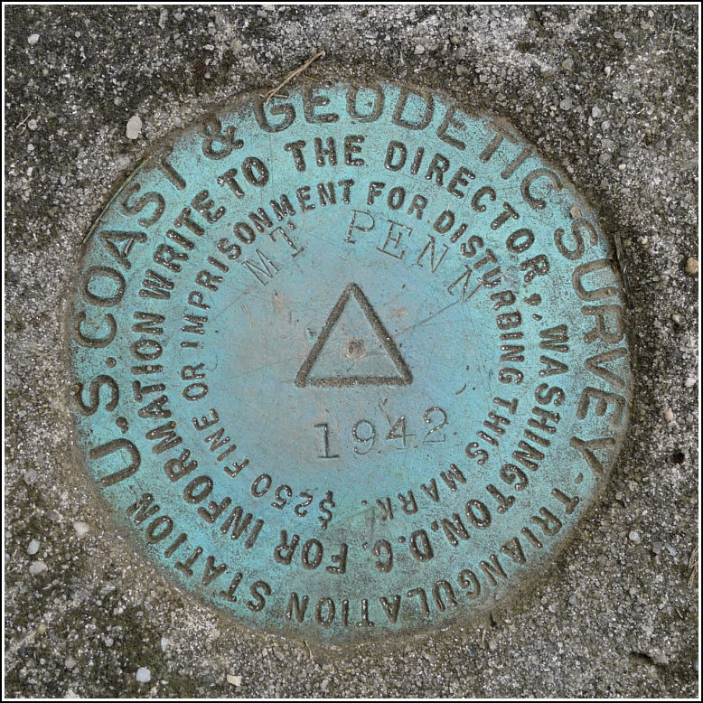
MT PENN (KV3830)
MT PENN
Spatial/elevation data
| Coordinates | N 40.34708° W 75.902486° |
| Elevation | 1119 ft. |
| Location | Pennsylvania
Berks County Reading Quad |
Mark description
| Type | Triangulation Station Disk |
| Setting | Square Concrete Monument |
| Monumented | 1942 by NGS |
| Description (NGS) | NGS Datasheet |
NGS recovery information
Descriptive text
The station was found in good condition in a square concrete monument near the Mt. Penn Lookout Tower, as described. Reference mark 1 and 2 were not found. Reference mark 1 may still exist beneath ground level near the stone wall east of the lookout tower. A metal detector would aid in the search. Reference mark 2 is probably lost. Only a foundation remains from the hotel and no water fountain base was found at the site, but pipes indicate the fountain’s probable former location.Narrative and photographs
For a few months, ever since Dad mentioned it, Rich and I have been looking forward to the Reading Air Show. Not only would it give us a chance to see some cool planes and awesome flying (which turned out even better than expected), but it would also give us the chance to look for a few benchmarks in a new area. Dad, of course, was on board with the idea and I’m not so sure about Mom but since she came along for the ride, well, she was along for the ride.
The first station we found was the Mt. Penn lookout tower (KV3831), followed immediately by this triangulation station just a few yards away from the fence around the tower. The station was an easy find and is in excellent condition. Although the monument is flush with the ground, the grass is obviously mowed here, so the monument and disk remain exposed.
But at the site of RM 1’s coordinates, east of the tower near the stone wall, the weeds are high and it appears that the area may have been regraded to widen the gravel road encircling the lookout tower. We couldn’t find any sign of the reference mark disk or monument.
We had a similar experience when looking for RM 2 at the ruins of the old hotel south of the lookout tower. Enough remains of the foundation for us to feel confident that we would find something, but unfortunately, the drinking fountain is long gone as is its base. The old pipes at the site of the coordinates are further evidence that we were in the right spot, though. We are confident in saying that RM 2 is gone, and RM 1 may still be in place but beneath the surface.
The postcard views below show the old tower (in approximately the same location as MT PENN LOOKOUT TOWER) with the hotel in the background, and a close-up view of the hotel. Although the drinking fountain isn’t visible in either view, the close-up view makes it really easy to tell how the hotel looked and how it was oriented at the site. We can easily match the foundation walls to the ruins that remain. The trolley is part of the Mt. Penn Gravity Railroad, which initially used steam locomotives but was electrified in 1898. See the Berks History Center for more.


.")


| Designation | Status | Condition | Image |
|---|---|---|---|
| MT PENN RM 1 | Not Found | Unknown (Not Found) |

|
| MT PENN RM 2 | Not Found | Unknown (Not Found) |
|