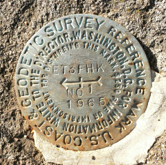
ET 3 FHK (HW3270)
ET 3 FHK
Spatial/elevation data
| Coordinates | N 38.611683° W 78.362783° |
| Elevation | 3097 ft. |
| Location | Virginia
Page County Old Rag Mountain Quad |
Mark description
| Type | Bench Mark Disk |
| Setting | Boulder |
| Monumented | 1965 by USGS |
| Description (NGS) | NGS Datasheet |
NGS recovery information
Descriptive text
Station mark not found. The ground was probed, but no evidence was found of the station disk or of the 3 by 3 foot boulder that once held the disk. RM 1 was found in good condition as described. The stem of RM 2 was found as described in the rock wall, but the disk is missing. The azimuth mark was not searched for at this time. Handheld GPS WAAS-corrected coordinates for RM 1 are 38 36 42.9(N) 078 21 45.6(W). Handheld GPS WAAS-corrected coordinates for RM 2 are 38 36 42.4(N) 078 21 46.3(W).Narrative and photographs
This tri-station (or rather, what little we found of the set of marks) was a surprise. I hadn’t printed out the datasheet before our trip and was therefore unaware of any marks at the Stony Man Overlook. But as soon as we pulled off Skyline Drive to take in the view, Rich looked to his left and spotted a boulder—I think he even said “That would be a nice spot for a disk”—and then a second later noticed a disk on top! We investigated and found it to be ET 3 FHK RM 1, for which I soon realized I had no datasheet.
With only the directional arrow on RM 1 to follow, we searched in vain for the station disk in the thin strip of grass and weeds between Skyline Drive and the parking pull-off. While Rich probed the ground, I wandered around a bit and soon discovered the remaining stem of what I presumed to have been RM 2, set in the rock wall at the edge of the overlook. This allowed us to zero in somewhat on the probable location of the station disk, but another twenty minutes or so of probing yielded nothing.
Without a datasheet, we were unaware of the nearby azimuth mark (which likely still exists). When we return to the park, I’d like to take another quick look for the station putting the datasheet measurements and compass bearings to use, even though we saw nothing resembling a 3 by 3-foot boulder at the site. I’d also like to find the azimuth mark.
| Designation | Status | Condition | Image |
|---|---|---|---|
| ET 3 FHK RM 1 | Recovered | Good |
|
| ET 3 FHK RM 2 | Not Found | Poor |

|