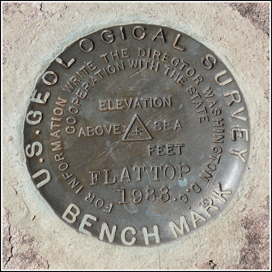
FLATTOP (ER0546)
FLATTOP
Spatial/elevation data
| Coordinates | N 34.823483° W 109.820466° |
| Elevation | 5856 ft. |
| Location | Arizona
Apache County Agate House Quad |
Mark description
| Type | Triangulation Station Disk |
| Setting | Rock Outcrop |
| Monumented | 1936 by USGS |
| Description (NGS) | NGS Datasheet |
NGS recovery information
Descriptive text
The station, both reference marks, and the azimuth mark were recovered in good condition. The station mark is located at the base of a large rock cairn. The summit sign near the azimuth mark was not found, but a witness sign is posted at the azimuth mark. Handheld GPS WAAS-corrected coordinates for RM 1 are 34 49 24.8(N) 109 49 13.7(W). Handheld GPS WAAS-corrected coordinates for RM 2 are 34 49 24.7(N) 109 49 13.1(W). Handheld GPS WAAS-corrected coordinates for the azimuth mark are 34 49 48.4(N) 109 49 25.6(W).Narrative and photographs
This has to be one of the craziest hikes we’ve ever done to search for a triangulation station! I still can’t believe how far off our expectations were from the reality of what we encountered on the hike.
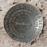
We began our morning as usual, with breakfast and a drive into the park. We first stopped at the Petrified Forest Rainbow Forest Museum (at the Visitors Center), and then headed northeast along Petrified Forest Road toward the Flattops. There is a convenient pulloff on the south side of the road and a narrow trail leading south toward the station coordinates, so we figured we were all set and would simply need to follow the trail to the top. We even spotted the azimuth mark right away due to its obvious witness post. It’s just north of the road, directly across from the pulloff where we parked. But we decided to leave that recovery for later, and we headed south along the trail.
It didn’t take very long before the trail petered out, and soon we were certain that the “15 minute pack” mentioned in the description was either a typo or someone’s extremely over-ambitious estimate. The mesa wall rose before us, but before we could reach the top we had in front of us at least an hour’s worth (probably more) of intricate, labyrinthine, fractal-like rock formations to traverse, somehow. And it was a real challenge! We felt like we were barely gaining any ground and, at times, even seemed to be going backward as we inched our way up and down through the rock. It was such a beautiful area, and would be so much fun to explore again when we don’t have a particular goal, like the tri-station recovery, in mind. At the time, it was both slightly frustrating and really hilarious!
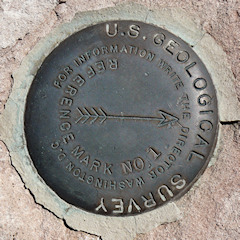
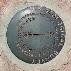
At least the conditions were perfect, and we were comfortable temperature-wise the entire time. We eventually made our way to the top, where we easily found the station disk and both reference marks. The station disk is just a few inches from the base of an enormous cairn, and for a moment I feared that the disk might actually be underneath the cairn! (We’ve never encountered a mark like that, but I have read descriptions of them.) Fortunately the mark was indeed exposed and was an easy find. All three marks on the Flattops are in excellent condition.
It took less time to descend; probably having some idea what we were in for helped tame our expectations, and we just calmly and carefully picked our way back through the rocks toward the car. Once there, we did our recovery of the azimuth mark to complete the set. This was a spectacular adventure that we will always remember fondly!


| Designation | Status | Condition | Image |
|---|---|---|---|
| FLATTOP AZ MK | Recovered | Good |
|
| FLATTOP RM 1 | Recovered | Good |
|
| FLATTOP RM 2 | Recovered | Good |
|