MOSER RESET (AA1487)
MOSER RESET
Spatial/elevation data
| Coordinates | N 24.703409° W 81.155306° |
| Elevation | 3 ft. |
| Location | Florida
Monroe County Sevenmile Bridge Quad |
Mark description
| Type | Triangulation Station Disk |
| Setting | Round Concrete Monument |
| Monumented | 1935 by NGS |
| Description (NGS) | NGS Datasheet |
Narrative and photographs
While we were visiting Pigeon Key today, we had a few benchmarks in mind to search for (of course)! MOSER RESET sounded like an interesting one, but unfortunately we were only able to find one of the reference marks. The station mark, with its adjusted coordinates, should have been an easy find, so we suspect it has been covered over by fill. The coordinates took us to an area just beneath a relatively new structure supporting solar panels, and the mark may have been covered or destroyed during its construction. The mark was last recovered by a geocacher in 2009.
RM 3 also eluded us, but in this case it was clear that the mark is gone. It had been set into a corner of a concrete pad that once apparently held a picnic table. That particular corner of the pad has clearly been removed, though! I can’t even speculate as to the reason. This concrete pad is on the eastern side of the fish pond.
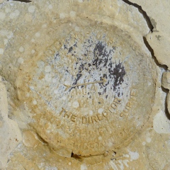
We were able to find RM 4. It was set into another concrete pad, on the western side of the fish pond, that still serves as a foundation for a picnic table. The disk is in good condition.
We didn’t attempt to search for the azimuth mark. It was believed to be destroyed in 1976 by bridge construction.
| Designation | Status | Condition | Image |
|---|---|---|---|
| MOSER RESET RM 3 | Not Found | Unknown (Not Found) |

|
| MOSER RM 4 | Recovered | Good |
|