41 B
41 B
Spatial/elevation data
| Coordinates | N 41.42153° W 75.93086° |
| Elevation | 1274.763 ft. |
| Location | Pennsylvania
Wyoming County Center Moreland Quad |
Mark description
| Type | Bench Mark Disk |
| Setting | Rock Outcrop |
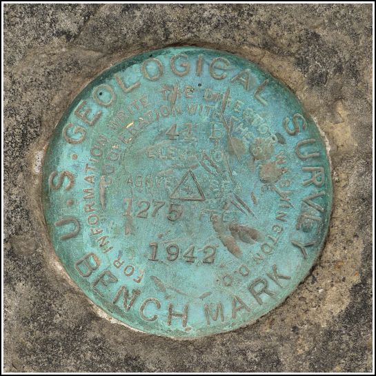
| Monumented | 1942 by USGS |
| Description (USGS) | Center Moreland, in village of; about 470 ft NW. of crossroad; 21 ft NE. of center of rd.; 12 ft NW. of W. corner of dwelling of Carrie Schrader; in ledge outcrop; standard tablet stamped “41 B 1942 1275” |
Narrative and photographs
I really like benchmarks near people’s houses, especially when there is no way the homeowners are unaware of the disk. Sometimes they can tell us more about the benchmark, and other times we can enlighten them about that metal disk they’ve built their rock garden around, but never knew the purpose of. Either way, we’re usually guaranteed an interesting encounter—if anyone’s home at the time.
I looked forward to the search for 41 B, set in an outcrop near a house in Center Moreland. We weren’t quite sure where to look because there are several very large bedrock outcrops in the immediate area, but Rich spotted the bright blue-green disk quite easily on a prominent ledge near a house as we drove slowly by, The ledge is along a short path between the porch of a house and the main road. The homeowners must be aware of it. I was disappointed, though, to find that no one was home when we visited. We can try again. I’d love to find out what the property owners might know about the mark, and it would also be interesting to know if they have any connection to the woman named in the original description (Carrie Schrader).
Back at home, I searched for records of Carrie Schrader in Center Moreland. I found this census record from 1940. She was born in 1889 and, in 1940, lived in the house with her husband Elmer and daughter Joan.


