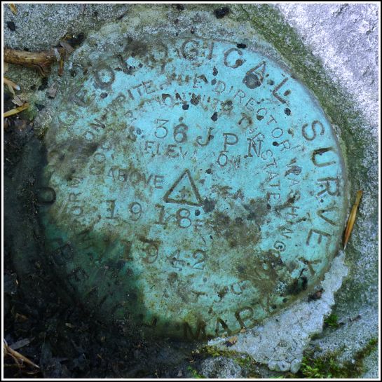
36 JPN
36 JPN
Spatial/elevation data
| Coordinates | N 41.27512° W 75.50595° |
| Elevation | 1918.402 ft. |
| Location | Pennsylvania
Lackawanna County Moscow Quad |
Mark description
| Type | Bench Mark Disk |
| Setting | Boulder |
| Monumented | 1942 by USGS |
| Description (USGS) | Daleville, 2.2 mi S. of; 75 ft N. and 120 ft E. from junction of State Highways 611 and 307 and rd. E.; in embedded boulder; standard tablet stamped “36 JPN 1942 1918” |
Narrative and photographs
Next on the list after our strikeout at 35 JPN was 36 JPN. This was a relatively easy find in a wooded lot directly east of the t-intersection of PA Route 435 and Covington Lake Drive.
A quick reading of the description can be confusing. State Highways 611 and 307, a formerly multiplexed route, is now simply PA Route 435. Another potentially confusing aspect is that the “rd. E.” no longer exists. A powerline passes through a nearby opening to the south that may have once been a road or track road, but at about 160 feet south, it is further away from the mark than 75 feet, so we’re not sure if this was the road referenced in the description.
The disk is in good condition, although it was half-buried under soil and leaf litter when I found it and will probably become covered again in a short time.


