Where Was Beacon 52?
Richmond—Washington Beacon 52
by Stephen Bennett
The problem

The lat/lon position given by the NGS data sheet[1] for Richmond—Washington Airway Beacon 52 does not match the description given. Why? I did some research and these are my findings. So where was it actually located?
First possible answer
The NGS data sheet[1] says Richmond—Washington Beacon 52 was located at POSITION - 38 19 33.47086(N) 077 10 38.12877(W). This is the present day location of Caledon State Park in King George County, Virginia.
A 1948 USGS topo map titled “Nanjemoy”[2] seems to agree with the coordinates given by the NGS data sheet, but it only shows “Airway Beacon”. It does not specify Beacon 52.
But wait. Something isn’t right! The description given in the NGS data sheet describes the location as follows:
"IT IS ON THE TIP OF A POINT OF LAND, ON THE W BANK OF THE POTOMAC RIVER, ABOUT 3.5 MILES E OF THE SMALL VILLAGE OF BROOKE."
The description given of the location by NGS does not match the coordinates given. The coordinates given by the NGS data sheet are not on the tip of a point of land, and they are not 3.5 miles east of Brooke. The given coordinates are nearly 12 miles southeast of Brooke.
Second possible answer
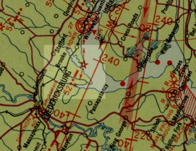
An aeronautical strip map[3] of the Richmond to Washington route shows beacon 52 (as described by the NGS) on a point of land 3.5 miles east of Brooke. This point of land is called Brent Point and is mostly owned by Widewater State Park. Dominion Power had planned to put a power plant there but instead sold it to the state to become Widewater park.
This location for beacon 52 is also corroborated by an air navigation map of the route from Washington to Savannah[4].
Interesting 1952 imagery


I attempted to use aerial imagery to prove or disprove one location vs. the other. The only imagery-related evidence I found that may cause me to lean one way or the other was this 1952 aerial photo of Brent Point. It’s not a smoking gun by any means—more like a grainy Bigfoot photo. What do you think? Could this be it? The area appears to have been fenced off. Could a tax map of Stafford County shed some light on past ownership of the small parcel?
The red lines in the second image are Google Earth’s measuring tool which indicated 50 feet. (Each red line is 50 feet long.) Could one of these two long narrow objects be a concrete arrow? They both appear to have points but in opposite directions.
Summary
Which was correct? The NGS coordinates or the NGS description? In this writer’s opinion there is strong evidence (though not conclusive) to suggest that beacon 52 was located at Brent Point (the location shown in the air charts[3,4] and as described in the NGS data sheet[1]) and not at the coordinates given in the NGS data sheet. I come to this conclusion for the following reasons:
- Brent Point is a much better match of the NGS description of the location being 3.5 miles E of Brooke and on a point of land.
- Taking into consideration the path along the beacons, beacon 52 is a better fit at Brent Point than at the NGS coordinates.
References
- NGS data sheet, PID HV5394: https://www.ngs.noaa.gov/cgi-bin/ds_mark.prl?PidBox=HV5394
- USGS topo map of Nanjemoy, MD quad, 1948: retrieved 14 Feb. 2021 from USGS topoView Historical Map Viewer.
- Airway Map No. 130,Richmond Va. to Washington D.C., 1935: https://www.loc.gov/resource/g3701pm.gct00064/?sp=160
- Air Navigation Map No. 59, Washington, D.C. to Savannah, Ga., 1936: https://www.loc.gov/resource/g3701pm.gct00064/?sp=131
- Aerial single frame photo, 1OQ0000020101.tif: https://earthexplorer.usgs.gov/