Existing Airway Beacons

Here are some photos of existing airway beacons, contributed by Dick Merrill.

Leadville, CO airport/airway beacon

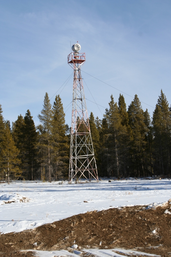
The Leadville beacon is on the grounds of the Leadville airport and was probably part of the airway beacon system. It is identical to an airway beacon except for the green lens. (Airway beacons were white on both sides while airport beacons are white and green.)

Longview, TX airway beacon

The Longview beacon is in the yard of a farm off of Highway 59 just north of Longview, Texas. The light is gone, but the tower is all intact.

Beacon 23 near Kingsport, TN

The last photo is of Beacon 23 near Kingsport, Tennessee on Chimney Top Mountain. It can be seen from I-81 but it is not obvious; binoculars help.


Posted on

by Zhanna

| Tagged: airway beacons

4 thoughts on “Existing Airway Beacons”

    • The old airway beacon is still mounted at the highest part of Chimney Top Mountain (3,118′ MSL) and is approximately 14.8nm WSW of the TRI airport. You can see its location on old (1930’s-1950’s) USGS topographic charts for Lovelace, TN. Using modern technology, you can find the beacon (and the old stubby little fire tower on the SW peak) by using Google Earth. Takes a little bit of patience but using my data, you’ll find it.

      I hiked up to the fire tower and nav beacon yesterday (3/26/23) and I must say it was grueling. A combination of rocky terrain and punishing grades would kick the heck out of a mountain goat! The final ascent up the “chimney” is challenging and dangerous without ropes. You really gotta hug them rocks!

      Reply
    • Hello Michael,

      Thanks for your comment!

      I’m assuming that you’re referring to a Geodetic Triangulation Station marker? These are one of many different types of survey markers in use for various purposes. Geodesy is the science of measuring and modeling the shape and other attributes (such as gravity, magnetism, and tides) of the earth. Both geodetic and land surveyors (the type you would hire to determine your property boundaries) use survey markers in their work, as do mapmakers and civil engineers—basically anyone who has a need to know their exact location and/or elevation.

      A geodetic triangulation station marks a precise location on the earth. It is typically part of a network of many such marks called, in the U.S., the National Spatial Reference System. (For more, see: http://www.ngs.noaa.gov/INFO/OnePagers/NSRSOnePager.pdf) Triangulation stations are considered “horizontal control”: they mark a precise latitude/longitude position, such as you would see on your GPS unit.

      “Vertical control” marks a precise elevation, rather than latitude/longitude. Hobbyist hunters often refer to all types of markers as “benchmarks,” although technically that is not correct. Only certain kinds of elevation marks are referred to as benchmarks (or bench marks) by surveyors.

      This page shows some of the different types of markers: https://thesurveystation.com/manual-of-geodetic-triangulation-excerpts/standard-marks/

      As you can probably tell by looking through my gallery of images (for example, 2014: https://thesurveystation.com/recoveries-gallery/2014-2/), I enjoy searching for survey markers of all kinds. If you are interested in looking for more, you might want to check out the Geocaching.com benchmark section:

      http://www.geocaching.com/mark/

      Also, the National Geodetic Survey has an interactive map here:

      http://www.ngs.noaa.gov/NGSDataExplorer/

      If you can send a photo or some more information about any stamping on the mark, I can tell you more about it!

      I hope this helps, but please don’t hesitate to ask more questions, and send an image of the mark (or its general location) if you can.

      Reply

Leave a Reply to michael Cancel reply